
Updated July 7, 2026
Rock River VermontVisitor guide near Newfane & Brattleboro
Route 30 parking, trail map, and live conditions—updated post–July 4, 2026.
Real river days
July on the banks
Warm water, easy company, and a lot of smiles — come see why people keep coming back.


On the trail
Bring your people
The walk in is half the fun — friends, shade, and good light the whole way to the water.


First visit
Park, walk, find your spot
The questions people ask most—parking on Route 30, the walk from the pull-off to the water, which banks to use, and what LGBTQ visitors want to know before arriving.
- 1
Park on Route 30
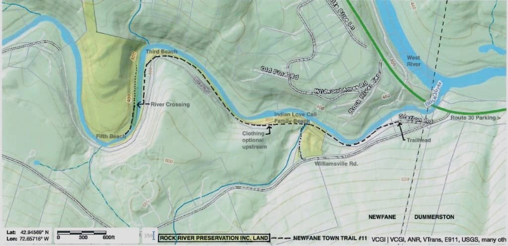
Use marked public pull-offs on VT Route 30 near Depot Road—match the pins on the map before you drive. No driveways, shoulders, or road paint. A full pull-off means the shore is busy; have a backup plan.
- 2
Walk the trail in
Most visitors reach the river in about 5–10 minutes on an uneven woodland trail—roots, wet rock, and short drops. Wear grippy shoes and keep your hands free. Save the map offline; cell service fades in the corridor.
- 3
Pick your bank
The first clear pools near the trail are the busy family beach. Farther upstream the banks open into quieter ledges and mixed-use shoreline with a long LGBTQ-friendly history. The map labels the main pools and pull-offs.
Quick answers
Where do I park for Rock River Vermont?+
Park only in marked public pull-offs on Route 30 near the Depot Road corridor on the Dummerston side. Open the map pins before you drive, respect posted signs and road paint, and never block driveways or gates. If legal parking is full, the river is at capacity—choose another time or plan.
How do I get from the parking lot to the river?+
From a legal Route 30 pull-off, follow the signed woodland trail downhill toward the water. The walk is usually 5–10 minutes on rocky, uneven tread. Stay on the marked route, wear shoes with grip, and use the map or trail film if you want to preview the walk before you go.
How long is the Rock River trail from parking?+
Plan on roughly 5–10 minutes each way for most visitors. The trail is short but not flat—expect roots, mud after rain, and slick ledge near the water. Allow extra time if you are carrying coolers or walking with kids.
Which beach or swimming hole should I use first?+
The first open pools you reach from the main trail are the busiest sandy/rocky beach—usually clothed, family-style use. Farther upstream along the river are additional ledges and pools with more mixed and LGBTQ-friendly shoreline culture. Use the map to see how the pools line up before you choose a spot.
Is Rock River gay friendly?+
Yes. Rock River has a long gay, bi, and queer presence, especially on some of the farther banks. It is still a shared natural place—give people privacy, keep voices low, do not photograph strangers, and follow posted signs. The LGBTQ guide covers culture, parking, and first-visit basics.
Can I bring a dog to Rock River?+
Please leave dogs at home. Narrow trails, quiet banks, and wildlife make Rock River a better visit without pets. Thanks for planning around that.
Is Rock River clothing optional or nude?+
Some stretches have a long clothing-optional history, but posted signs, steward guidance, and privacy norms come first. Do not assume every pool is the same—the first beach near the trail is usually clothed. Read the clothing-optional guide for respectful context before you go.
What if Route 30 parking is full?+
A full pull-off means the shore is already busy. Do not park on shoulders, in driveways, or on private land. Loop back, try another day or an earlier arrival, or use your backup plan. Overflow parking is not provided.
Are there bathrooms at Rock River?+
No on-site restrooms, showers, or changing rooms. Use a gas station or café in Brattleboro, Newfane, or along Route 30 before you arrive, and pack out everything you bring.
Will my phone work at Rock River?+
Cell service is spotty in the river corridor. Download the map, directions, and any notes you need before you leave Brattleboro or Route 30. The site works offline once pages are loaded in your browser.
How far is Rock River from Brattleboro?+
About 15–20 minutes north on Route 30 toward the Newfane and Dummerston corridor. There is no single street address—navigate to the Route 30 / Depot Road pull-offs using the map pins, not a town name alone.
What is different after the Fourth of July weekend?+
Early July weekends—including the holiday—fill Route 30 pull-offs by mid-morning. Midweek and early mornings stay calmer. Pools still run cool against hot air; storms upstream can lift the river overnight. Open live conditions before you drive.
Where is Rock River Vermont?+
Southern Vermont, Windham County, near Newfane, Dummerston, and Brattleboro. Most searches mean the lower swimming-hole corridor reached from Route 30 near Depot Road—not the northern Rock River tied to Lake Champlain.
Is Rock River in Newfane or Dummerston?+
Both town names appear in search results because the corridor spans Windham County labels. For visiting, use Route 30 near Depot Road, the map pins, and posted pull-offs rather than a single town name.
Is this the same Rock River as northern Vermont?+
No. This guide covers the southern Vermont Rock River near Newfane, Dummerston, Brattleboro, Route 30, and Depot Road—not the northern river connected with Franklin, Highgate, Quebec, or Lake Champlain.
Rock River Vermont is a southern Vermont swimming-hole corridor near Newfane, Dummerston, and Brattleboro. You park in marked Route 30 pull-offs near Depot Road, walk 5–10 minutes on a rocky trail, then pick a bank along the pools. Start with the parking & Q&A, map, and LGBTQ guide—then open live conditions before you drive.
July on the river
Clear water, green banks, summer light
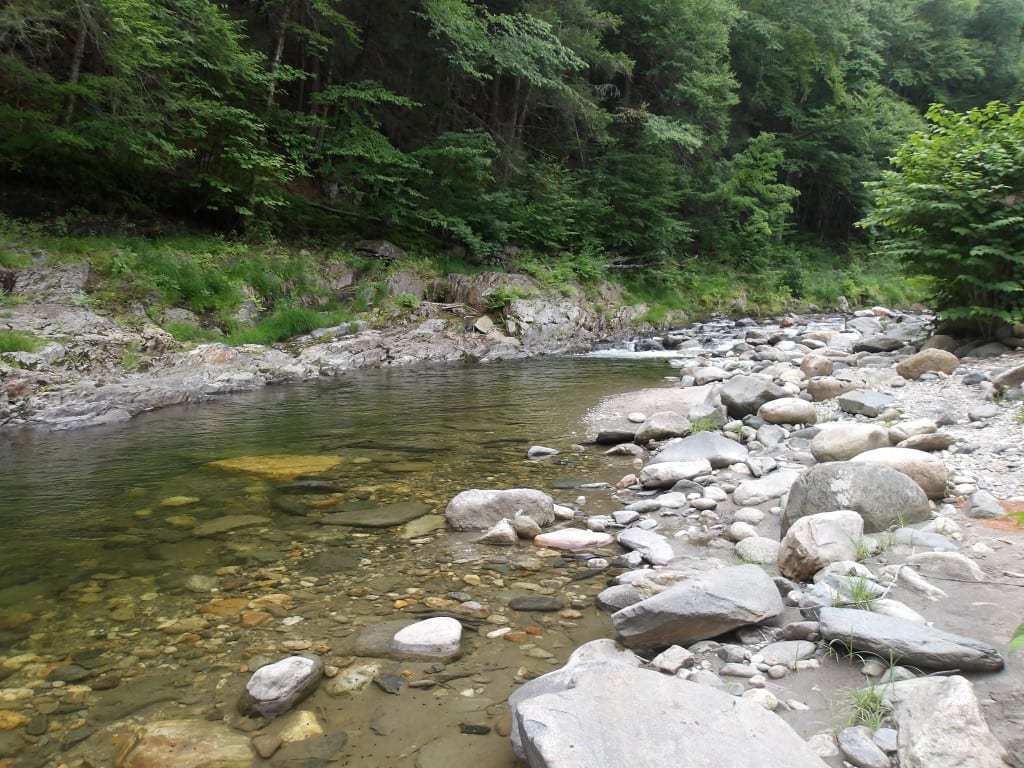
July brings the long warm days people picture: shallow pools over smooth stone, forest shade along the banks, and room to spread out when you arrive early. The walk in still matters—roots, moss, and woodland detail line the trail before the river opens up.
Along the corridor
Stones, forest, and summer detail


Should you head out?
Live weather, parking, and river readouts load when you scroll here or after the hero settles—static planning copy stays visible for search either way.
Popular searches
What people look for on Rock River Vermont
Rock River today
After the Fourth
Holiday weekend traffic has eased into a steadier July rhythm—weekdays and early mornings are the sweet spot now. Route 30 pull-offs still fill on sunny Saturdays, so arrive early, save the map offline, and wade in…
Rock River Vermont quick answer
Rock River Vermont: where it is, how to visit, and what to plan first
Rock River Vermont usually means the southern Vermont swimming-hole corridor near Newfane and Dummerston, a short drive from Brattleboro. Visitors use the Route 30 / Depot Road area for legal parking, then walk an uneven woodland trail toward cold pools, ledges, and preserved riverbank.
This site is an independent, neighbor-run visitor guide for planning a respectful Rock River visit. Use it for the map, parking notes, current conditions, trail overview, water-safety reminders, privacy-first etiquette, LGBTQ-friendly visitor context, and what to plan before you drive.
Rock River has a long LGBTQ-friendly and clothing-optional history, but it is still a shared natural place first. Open live conditions, use marked parking only, avoid photos of strangers, keep voices low, pack out everything, and follow posted signs and steward guidance.
This guide is about the southern Vermont Rock River near Newfane, Dummerston, Route 30, Depot Road, Brattleboro, and the West River. It is not the northern Rock River connected with Franklin, Highgate, Quebec, Missisquoi Bay, or Lake Champlain.
Quick facts
- Place
- Rock River, southern Vermont
- Common searches
- Rock River Vermont, Rock River VT, Rock River Newfane, Rock River Dummerston
- Nearby towns
- Newfane, Dummerston, Brattleboro
- Practical access phrase
- Route 30 near Depot Road
- Main visitor use
- Swimming holes, rocky pools, ledges, short walk-in trail
- Parking
- Marked public pull-offs only
- Trail
- Uneven woodland trail with roots, wet stone, mud, and ledge
- Facilities
- No restrooms, showers, trash cans, vendors, or lifeguards
- Culture
- LGBTQ-friendly history, privacy-first etiquette, shared natural shoreline
- Early July 2026
- Post–Fourth of July: weekday mornings are calmest; weekends fill Route 30 early. Map, parking pins, 5–10 min trail, cool pools—save directions offline
More detail
Extended Rock River FAQ
- Where do I park for Rock River Vermont?
- Park only in marked public pull-offs on Route 30 near the Depot Road corridor on the Dummerston side. Open the map pins before you drive, respect posted signs and road paint, and never block driveways or gates. If legal parking is full, the river is at capacity—choose another time or plan.
- How do I get from the parking lot to the river?
- From a legal Route 30 pull-off, follow the signed woodland trail downhill toward the water. The walk is usually 5–10 minutes on rocky, uneven tread. Stay on the marked route, wear shoes with grip, and use the map or trail film if you want to preview the walk before you go.
- How long is the Rock River trail from parking?
- Plan on roughly 5–10 minutes each way for most visitors. The trail is short but not flat—expect roots, mud after rain, and slick ledge near the water. Allow extra time if you are carrying coolers or walking with kids.
- Which beach or swimming hole should I use first?
- The first open pools you reach from the main trail are the busiest sandy/rocky beach—usually clothed, family-style use. Farther upstream along the river are additional ledges and pools with more mixed and LGBTQ-friendly shoreline culture. Use the map to see how the pools line up before you choose a spot.
- Is Rock River gay friendly?
- Yes. Rock River has a long gay, bi, and queer presence, especially on some of the farther banks. It is still a shared natural place—give people privacy, keep voices low, do not photograph strangers, and follow posted signs. The LGBTQ guide covers culture, parking, and first-visit basics.
- Can I bring a dog to Rock River?
- Please leave dogs at home. Narrow trails, quiet banks, and wildlife make Rock River a better visit without pets. Thanks for planning around that.
See all parking, trail, and beach Q&A ↑
Source transparency
Why this guide exists
RockRiverVT is an independent, visitor-run, privacy-first guide. It is not the town, state, Rock River Preservation, or any official access manager. We link to stewardship groups, town notices, and regional water-quality resources so you can verify facts and plan a careful visit.
- Rock River Preservation
- Town of Newfane Route 30 parking notice
- Vermont River Conservancy water quality
- Full links and resources page
Guide reviewed .