Rock River VT map: parking, trail & swimming holes
Parking, walk-in path, and where the main swim spots sit in relation to Route 30 and Depot Road—one visitor-facing map for the Newfane / Dummerston access story.
Rock River map legend
Use this map before you drive. The important planning landmarks are VT Route 30, the Depot Road area, marked public pull-offs, the walk-in trail, the Rock River crossing, and the lower swimming-hole corridor. Cell service can fade near the river, so load the map and directions before arriving.
What the pins mean
- Parking: marked Route 30 pull-offs near Depot Road.
- Trail: uneven walk-in route with roots, ledge, mud, and wet stone.
- Water: swimming-hole orientation only, not a guarantee of safety or access.
- Respect: posted signs, steward guidance, private property, and current conditions come first.
Visiting because you heard about Rock River as an LGBTQ-friendly or clothing-optional swimming hole? Read the Rock River LGBTQ guide before you drive.
Rock River trail map and parking overview
Same pins, bigger picture: how Route 30, Depot Road, and the “which town is this?” labels line up. Load it before you drive—reception thins at the water. If the name game still annoys you, read Route 30 and Depot Road: Rock River parking and trail access.
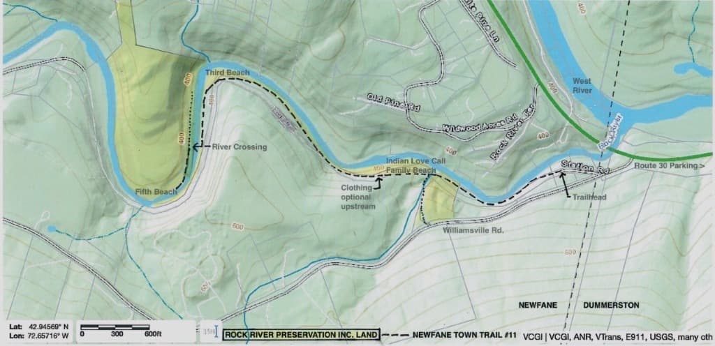
Rock River VT map: Route 30 parking, trail orientation, and swimming-hole access near Newfane and Dummerston.
Quick map answers
- What road should I remember?
- Remember VT Route 30 near Depot Road. Search results may say Newfane, Dummerston, Williamsville Road, or West River, but the practical visitor phrase is Route 30 near Depot Road.
- Where is the Rock River trailhead?
- Use the Route 30 corridor near Depot Road and follow current signs and marked public access.
- Where do I park for Rock River?
- Use marked public pull-offs only. Do not block driveways, gates, shoulders, road paint, or emergency access. See the Route 30 parking guide.
- Is this the Rock River map for swimming holes?
- Yes—pins for parking, the walk-in, and swim areas for this river access in Newfane and Dummerston, not a generic county map.
- Is the map enough by itself?
- No. Pair the map with current conditions, the parking guide, and posted signs when you arrive.
- Should I rely on cell service?
- No. Open or download the map before arriving.
Text directions: Rock River directions from Brattleboro and Newfane.
Rock River trail map and walk-in route
Use the interactive map below to match pins to the Route 30 parking map and the trail toward the main swimming-holes corridor.
Start here
Start at the Route 30 pull-offs near Depot Road in Dummerston. Use this Rock River map before you drive: parking is limited, trail access is uneven, cell service fades near the river, and people often describe the swimming holes as Rock River Newfane even when the parking landmark is closer to Depot Road.
Interactive map
Trail
Walk-through
Parking
Parking is limited and fills quickly on weekends. Use marked pull-offs only.
Route 30 near Depot Road (Dummerston side) — match the map pins and respect signs and paint.
Directions
Navigate to the Route 30 corridor near Depot Road, then use the map above for exact pull-offs and the trail. For text-only routing, open Rock River directions from Brattleboro and Newfane.
Open in Google MapsWhere do I park for Rock River?
Use marked public parking pull-offs on VT Route 30 near Depot Road, on the Dummerston side. Do not block driveways, gates, road shoulders, or no-parking paint. Open the map before you arrive, because cell service is limited near the Rock River trail.
Looking for the old Rock River map page? You are in the right place. Read the parking guide for Route 30 pull-off details.
Cell service is limited near the river — download directions before arriving.