Wayfinding
Rock River Parking
The river is on the map; the car is the puzzle. Marked Route 30 pull-offs first—read this, then match it to the map and paint on the ground.


Short version
Use marked Route 30 pull-offs only
Most visitors orient from signed recreation pull-offs on VT Route 30 near the Depot Road area, then walk down the trail toward the river. Town names and map labels can be confusing around Newfane, Dummerston, and the West River corridor, so use the Rock River trail map before you drive.
Never block driveways, gates, road shoulders, emergency access, or no-parking paint. If the pull-off is full, the river is full enough for you to choose another plan.
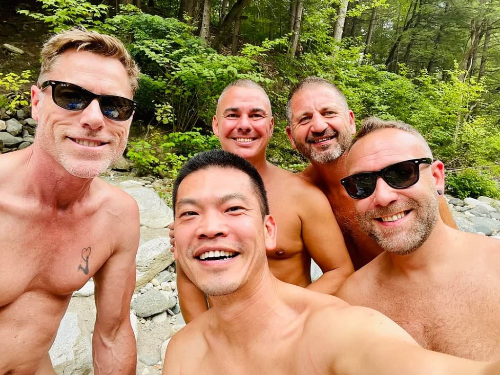
For LGBTQ and clothing-optional visitor context, start with the Rock River LGBTQ guide, then come back here before driving.
Rules of thumb
Parking basics that protect access
- Use marked pull-offs only.
- Do not block driveways, gates, paint, shoulders, or emergency access.
- Follow posted signs and road paint over anything you read online.
- Parking fills early on warm summer weekends and holidays—arrive early or come midweek.
- Download directions before arriving because cell service fades near the corridor.
- This guide is not official parking enforcement guidance.
Next step
Pair parking with directions and conditions
- Start with Map for pins and trail orientation.
- Save Directions before the signal fades.
- Open Conditions before leaving—especially after rain.
- Read Visit for the walk in, packing, and first-timer notes.
- Confused by Newfane vs Dummerston vs Depot Road? Read Route 30 and Depot Road.
Crowd
Parking tells you a lot
A crowded pull-off usually means a crowded trail and shore. That is not just inconvenient; it changes the feel of a narrow river corridor. If you want quiet, try weekday mornings, shoulder-season walks, or a different local stop after checking conditions.
The Community page has nearby context for after-river plans, but it is not a directory of secret overflow parking.
Respect
Good parking protects access
Search traffic can put pressure on small places. The simplest way to help Rock River remain welcoming is to park legally, keep noise low at the road, pack out trash, and treat nearby homes like homes. Posted signs and steward direction override anything you read online.
Questions
Common parking questions
- Where do I park for Rock River?
- Only at marked public pull-offs on Route 30 near the Depot Road corridor. Match the map pins, never use driveways or shoulders, and do not block gates or road paint.
- Is there overflow parking?
- There is no official overflow lot. If pull-offs are full, choose a different time or another local stop. Do not improvise on private land or the road edge.
- What if the pull-off is full?
- Treat a full pull-off as a sign the shore is at capacity. Loop back, come earlier another day, or use your backup plan.
- Can I park on the shoulder?
- No. Shoulders, driveways, and grass strips outside marked pull-offs put neighbors and emergency access at risk. Follow current signs and paint.